Related news
Telangana News
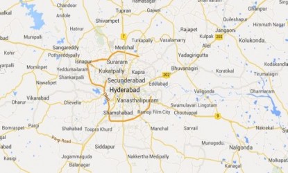
Google maps role in Telangana districts division
As per the order of the Telangana Chief Minister KCR, maps for about 24 to 26 districts will be prepared and submitted and basing on that, the Collector would prepare full length final maps.
The Telangana state government is fully using the advanced technical expertise along with the scientific knowledge, for the formation of the new districts in the state. Taking the standard of the google maps, the new districts, zones, revenue divisions.Irrespective of the population and other aspects, the geographical boundaries of the state, will be decided through the google maps, with the support of National Remote Sensing Agency (NRSA).